


2
Introduction
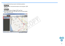
Map Utility version 1.4 is a software utility for viewing the shooting
locations of images shot with EOS DIGITAL cameras either with built-in
GPS*
1
functionality or used with a Canon GPS receiver. If you shoot
photos with an EOS 6D*
2
or with another EOS DIGITAL camera used
with GPS Receiver GP-E2, you can view them with the route you traveled
(motion paths).
*
1
GPS: Global Positioning System, a system of satellites used to
determine the current location
*
2
“EOS 6D” and in this manual indicate EOS 6D (WG), the
model equipped with an internal GPS receiver.
Downloading and Installing Map Utility Version 1.4
Map Utility version 1.4 is downloaded and installed automatically when
you install ImageBrowser EX from the EOS DIGITAL Solution Disk
(provided with the EOS 6D) on a computer with Internet access.
Main Features of Map Utility Version 1.4
Main features of Map Utility are as follows.
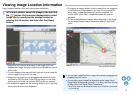
●
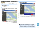
View where images were taken
● Import geotagged images and view shooting locations on a map.
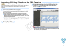
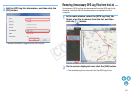
● Import GPS log files
● Connect the GP-E2 to a computer to import and save GPS log
files to the computer.
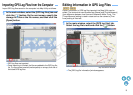
● Edit GPS log files
● You can edit information in imported GPS log files.
●
View routes traveled (motion paths)
● Import GPS log files from the GP-E2 or the EOS 6D to view the
routes traveled between shooting locations on a map.
EOS 6D
GP-E1
GP-E2
EOS 6D
GP-E2
GP-E2
EOS 6D
GP-E2
EOS 6D
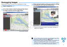
● Geotag images
● Use GPS log files from the GP-E2 or the EOS 6D to geotag
images without GPS information.
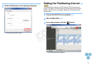
● Adjust the logging interval, delete
logs
● Connect the GP-E2 to a computer to adjust the receiver’s logging
interval, or to delete log information in the receiver.
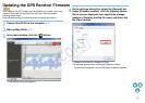
● Update GPS receiver firmware
● Connect the GP-E2 to a computer to update the receiver’s
firmware to the latest version.
● Other features
● You can search desired locations on a map, and save shooting
locations or other information displayed in Map Utility as Google
Earth™ files.
● For importing GPS log files in EOS 6D to the computer and
deleting the log information, use the EOS Utility software included
in the EOS DIGITAL Solution Disk provided with EOS 6D.
For details, refer to the EOS Utility Instruction Manual (PDF).
GP-E2
EOS 6D
GP-E2
GP-E2
● This software uses Google Maps™ to display images and routes
traveled on a map. Location information in images and GPS logs
is sent to service providers.
● Internet Service Provider (ISP) connection fees or access point
connection fees may apply.
● Geotagged images and GPS logs may contain personally
identifiable information. Be careful when sharing the files or
posting images online where many people can view them.
● Do not operate Map Utility while editing images with Digital Photo
Professional. Edited images may not be saved properly.
About ImageBrowser EX
ImageBrowser EX is required when installing or uninstalling Map
Utility.
When you start up ImageBrowser EX while connected to the
Internet, both ImageBrowser EX and Map Utility will be updated
automatically to the latest version, as needed.
C OPY