


124
Table of Contents Useful Recording Techniques Index
reach the camcorder as follows.
In tunnels, indoors or under the shade of
buildings.
Between tall buildings or at narrow streets
surrounded by buildings.
In underground locations, locations
surrounded by dense trees, under an elevated
bridge, or in locations where magnetic fields
are generated, such as near high voltage
cables.
Near devices that generate radio signals of the
same frequency band as the camcorder: near
1.5 GHz band mobile telephones, etc.
On triangulating errors
If you move to another location right after
setting the GPS switch to ON, it may take
a longer time for the camcorder to start
trianguating, compared to when you stay in the
same place.
Error caused by the position of GPS satellites
The camcorder automatically triangulates your
current location when the camcorder receives
radio signals from 3 or more GPS satellites. The
triangulating error allowed by the GPS satellites
is about 30 m (98 feet). Depending on the
environment of the location, the triangulating
error can be greater. In this case, your actual
location may not match the location on the map
based on the GPS information. Meanwhile,
the GPS satellites are controlled by the Unites
States Department of Defense, and the degree of
accuracy may be changed intentionally.
Error during the triangulating process
The camcorder acquires location information
every 10 seconds during triangulating.
There is a slight time difference between when
the location information is acquired and when
the location information is recorded on an
image, therefore, the actual recording location
may not match exactly the location on the map
based on the GPS information.
On the restriction of use of GPS on an
airplane
During take off and landing of an airplane,
set the GPS switch to OFF and turn off the
camcorder, as you will be instructed to do by
the on-board announcement. In other cases, use
GPS in accordance with the regulations of the
place or situation.
*
1
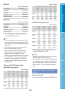
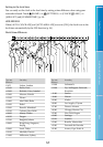
1080i specification
A high definition specification which utilizes
1,080 effective scanning lines and the interlace
system.
*
2
720p specification
A high definition specification which utilizes
720 effective scanning lines and the progressive
system.
*
3
Data recorded in AVCHD format other than
the above mentioned cannot be played on your
camcorder.
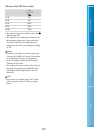
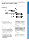
About GPS (HDR-XR200VE)
The GPS (Global Positioning System) is a
system that calculates geographical location
from highly accurate US space satellites.
This system allows you to pinpoint your
exact location on the earth. The GPS
satellites are located in 6 orbits, 20,000 km
above the earth. The GPS system consists
of 24 or more GPS satellites. A GPS receiver
receives radio signals from the satellites,
and calculates the current location of the
receiver based on the orbital information
(almanac data) and travel time of the
signals, etc.
Determining a location is called
“triangulating.” A GPS receiver can
determine the location’s latitude and
longitude by receiving signals from 3 or
more satellites.
As the positions of GPS satellites vary
constantly, it may take longer to determine
the location or the receiver may not be able to
determine the location at all, depending on the
location and time you use the camcorder.
“GPS” is a system for determining geographic
location by triangulating radio signals from
GPS satellites. Avoid using the camcorder
in places where radio signals are blocked or
reflected, such as a shadowy place surrounded
by buildings or trees, etc. Use the camcorder in
open sky environments.
You may not be able to record location
information at locations or in situations where
radio signals from the GPS satellites do not