


70 Smartphones and Tablet Devices
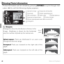
Location Data
Photo Navigation
Photo Navigation
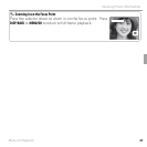
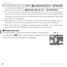
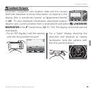
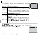
Use location data downloaded from a smartphone to show the direction and
distance from your present position to the location where a picture was taken:
1
Download data on your current location from a smartphone (P
66
).
2
Display a picture with a k icon.
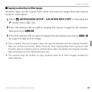
3
Select U PHOTO NAVIGATION in the F-mode menu
(P 104). The approximate direction and distance to the
location where the picture was taken are displayed as
shown, using the units selected for U GEOTAGGING
SET-UP> km/mile (P 105). Distances over 1000 units
are indicated by “>”, those under 100 units by “<”.
NE
<100
m
NE
<100
m
100-0001
100-0001
-
MINATO, TOKYO, JAPAN
R Photo navigation ends when the next picture is displayed.