


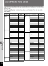

224
8
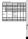
Appendix
Utilities Guide for GPS
Before Using the GPS
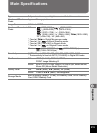
GPS means the Global Positioning System. The camera receives
signals from multiple GPS satellites to determine its position and the
time. This is called “positioning”.
Embeds location information on an image
Location information such as latitude and longitude of a shooting
location is recorded. The shooting location can be displayed on a map
by using the provided software.
Saves log files to the SD Memory Card
The camera receives signals from GPS satellites regularly and saves
GPS information to the SD Memory Card as a log file in KML format. The
log files can be imported to Google Earth, Google Maps or other
programs that can read KML files on a computer and your route can be
displayed on their maps.
*Google, Google Earth™ and Google Maps™ are trademarks of Google
Inc.
Corrects the camera clock using GPS information
The camera corrects its clock automatically using the time data received
from GPS satellites.
Displays the electronic compass on the screen
The camera has the Electronic Compass function that displays the lens
direction at the time of shooting on the screen.
When the camera receives signals from GPS satellites, it indicates the
orientation to true north using GPS location information. The location
information can be recorded on captured images.
When the camera does not receive any signals or the GPS function is
set to off, it indicates the orientation to magnetic north.
About the GPS
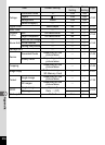
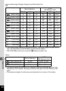
GPS Function on the RICOH WG-4
1 [Electronic Compass Display in Still Picture Capture Mode] (p.24)
This part applies only to the RICOH WG-4 GPS camera