


87
Using Location Data Functions/Displaying Maps
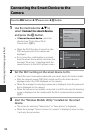
C Location Data Reception Indicator and Points of Interest (POI)
Information
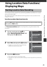
• Location data reception can be checked on the
shooting screen.
- n: Signals are being received from four or
more satellites and positioning is being
performed. The location data is recorded on
the image.
- o: Signals are being received from three
satellites and positioning is being performed.
The location data is recorded on the image.
- z: Signals are being received from the
satellites, but positioning is not possible. The
location data is not recorded on the image.
- y: Signals cannot be received from the satellites, and positioning is not possible.
The location data is not recorded on the image.
• POI information is location name information for landmarks (facilities) and other
details.
- When Display POI in Points of interest (POI) of the Location data options
menu (A91) is set to On, the nearest location name information for the current
position is displayed during shooting.
- When Embed POI is set to On, location name information can be recorded on
the image during shooting.
- If the location name information was recorded on the image during shooting,
this information is displayed when Display POI is set to On during playback.
• The location name information may not be displayed depending on the setting
level in Level of detail of Points of interest (POI). Also, certain landmark names
may not be registered, or the landmark name may be different.
C Images with Recorded Location Data
• The z icon is displayed during playback for images which have the location data
recorded (A8).
• The location data recorded on an image can be checked on a map with ViewNX 2
after transferring the image to a computer (A98).
• The actual place of shooting may differ from the location data recorded on the
image files due to the accuracy of the location data obtained and a difference in
the geodetic system used.
• The location data and POI information recorded on images can be erased using
Erase location data in Location data options (A91). The erased information
cannot be recovered.
25
m
0s25
m
0s
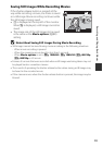
880880
1/2501/250 F3.7F3.7
Location data reception
Location name information
(POI information)