


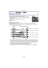

GPS/Sensor
- 122 -
Applicable modes:
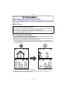
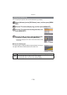
Using the altimeter
You can check the altitude of the current location.
•
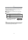
Displaying range is j600 m (–2000 feet) to 9000 m (30000 feet).
• A depth meter will be displayed instead of the altimeter in [Beach &
Snorkeling] mode.
For details about the depth meter, please read P74.
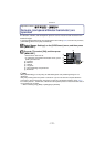
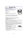
A Altitude
B Current altitude
∫ About altitude conversion
The displayed altitude is a relative altitude
¢
1
. The altitude is a value calculated by
converting an atmospheric pressure within the unit to an altitude with 0 m (0 feet) (sea
level) u 1013 hPa
¢
2
as a reference.
¢1 Altitude can be expressed in two forms — as an altitude above sea level (absolute height
from sea surface) or as a relative altitude (difference in altitude between two locations). This
unit displays a relative altitude estimated by a method which uses the relationship between
the altitude and atmospheric pressure in the ISA [International Standard Atmosphere], as
specified by the ICAO [International Civil Aviation Organization].
¢2 “hPa (hectopascal)” is a unit used to represent atmospheric pressure.
¢3 Readings fluctuate with the weather. Adjust frequently with [Adjust] (P123) in
[Altimeter].
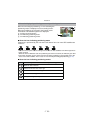
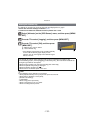
Altitude Atmospheric pressure
Approx. 8 hPa per 100 m (328 feet)
Approx. 9 hPa per 100 m (328 feet)
Approx. 10 hPa per 100 m (328 feet)
Approx. 11 hPa per 100 m (328 feet)
Approx. 12 hPa per 100 m (328 feet)
A B