


- 123 -
GPS/Sensor
The altimeter can be adjusted manually or using GPS.
To measure altitude with greater accuracy, we recommend that you perform [Adjust]
regularly by comparing a reference altitude on a sign or other accurate altitude information
with the altitude indicated by the unit.
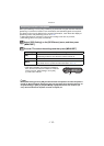
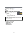
Select [Altimeter] on the [GPS/Sensor] menu, and then press [MENU/
SET].
Press 3/4 to select [Adjust], and then press [MENU/SET].
Press 3/4 to select the settings, and then press [MENU/SET].
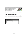
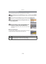
Adjusting the Altimeter
Settings Description of settings
[GPS]
Use the GPS information to adjust the altimeter.
•The [GPS Setting] turns [ON] automatically.
•The adjusted altitude may show errors of more than approximately
d50 m (164 feet) depending on the positions of the GPS satellites.
•When altitude adjusted based on successful positioning has an error
larger than this, we recommend that you select [ON] and make
manual adjustments.
•Even when GPS positioning is successful, the altitude can be
affected by satellite positioning and signal conditions. In this case,
the altimeter will not be adjusted.
•When [GPS Setting] is set to [OFF], [Adjust] is automatically set to
[ON].
[ON]
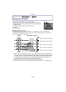
Adjust the altitude manually.
Press 2/1 to select the items, and press 3/4 to set.
•
It can be adjusted to between j599 m (–1999 feet) and 8999 m
(29999 feet).
[OFF]
The adjusted altitude value is restored to the value which is before you
adjust.