


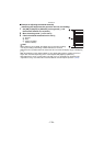

GPS/Sensor
- 124 -
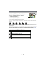
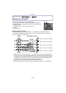
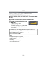
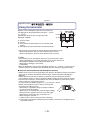
∫ Example of adjusting the altitude manually
(measuring the height from the ground to the roof of a building)
1 Set [ON] in [Adjust] in [Altimeter] on the ground A, and
then set the altimeter to 0 m (0 feet).
2 Move from the ground A to the roof B.
3 Check the altitude measured on the roof B.
A Ground
B Roof
C Height of building
(relative altitude)
Note
•
When [Adjust] is set to [GPS], the altitude prior to and after recording
can vary according to the timing at which GPS data is received.
• Adjustment is not possible when the measured value exceeds the display range. It will display
[----].
• With the displaying of the relative altitude, it may display with negative numbers even if it is
higher than sea level depending on the value adjusted with [Adjust] in [Altimeter].
• After adjustment, errors of a few metres may still occur. For information on preserving the
adjusted accuracy, read
“About the measured altitude and atmospheric pressure” (P128).