139
Using Location Data Functions/Displaying Maps
C Notes About Direction and Location Data Display
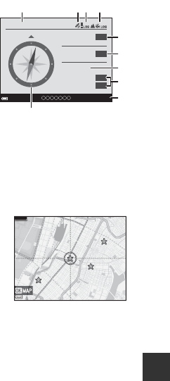
Direction or location data, etc. is displayed when a map is being displayed in
shooting mode or if the U button is held down while the power is off.
1 Date and time
2 Location data reception
3 Create log display (location data)
4 Create log display (altitude/water depth)
5 Altitude
6 Atmospheric pressure
7 Direction
8 Latitude and longitude
9 Location name information (Points of
Interest: POI)*
10 Compass display
* “----” may be displayed for the location name information depending on the
setting level in Level of detail of Points of interest (POI).
C Map Operations of Saved Locations
If you press the k button and select Center on
saved location while a map is displayed (A136,
138) or a thumbnail is selected (A144), the map
scrolls to the saved location that is closest to the
center of the screen.
• Use the multi selector HIJK to move to other
saved locations.
• Press the l button to cancel saving a location.
- Current location: Cancel saving of the selected location.
- Selected locations: Delete a batch of saved locations. Use the multi selector to
select a saved location and press the l button. Press the l button again to
deselect it. Press the k button after you finish selecting the locations.
- All locations: Delete the all saved locations at once.
• Press the k button to exit the operation screen.
15
/
11
/
2015 15:30
24
º
19’
21”
124
º
04’
37”
1010
NNE
1554
m
N
E
hPa
1 2 4
5
6
8
9
7
3
10
500m


