


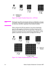
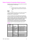

EN Raster Height Command 15-11
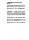
Raster Height Command
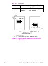
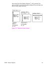
The Raster Height command specifies the height in raster rows of the
raster area. Height is the direction perpendicular to the direction that
raster rows are laid down, hence, height is subject to the current
raster presentation mode and print direction (see Figure 15-7).
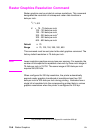
E
C
* r # T
# = Height in raster rows
Default = N/A
Range = 0 to (logical page length – current Y-position of the
0,cursor)
*
*
Greater values default to (logical page length – current Y-position of the cursor)
This command fills the raster area to the full raster height with zeroed
rows. Unspecified rows map to either white or transparent depending
on the source transparency mode.
When a Transfer Raster Data command is received that causes
any raster row to extend beyond the row boundary set by the Raster
Height command, the row outside the boundary is clipped. This
includes the case where the cursor is moved beyond the height
boundary with a Raster Y Offset command and the printing of raster
data is attempted.
If you have specified either a raster height or a raster width of 0
and a Start Raster Graphics (or Transfer Raster Data) command is
received, then the entire raster graphic is clipped. If both a raster
height and a raster width are specified (non-zero) and a Start Raster
Graphics (or Transfer Raster Data) command is received then the
raster area is guaranteed to be logically zeroed-out.
If the raster height is not set, the raster height is ignored so that no
padding or clipping of rows takes place.
This command is ignored after the Start Raster Graphics or Transfer
Raster Data commands until the next End Raster Graphics
command.
Note Only raster data appearing within the intersection of the logical page,
the printable area, and if set, the raster width and height is printed.
Data outside the intersection is clipped.