


167
GPS (G800SE Only)
15
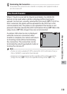
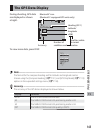
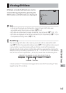
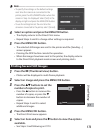
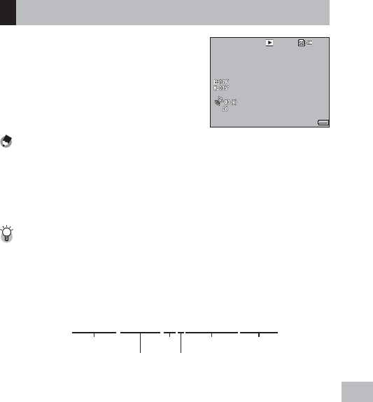
Viewing GPS Data
GPS data recorded with pictures can be
viewed during playback by pressing the
DISP. button until GPS data are displayed.
359.2˚//NNW/mag
359.2˚//NNW/mag
359.2˚//NNW/mag
2014
/
09
/
01 00:00
2014
/
09
/
01 00:00
2014
/
09
/
01 00:00 F3.5
F3.5
F3.5 1
/
1000
1
/
1000
1
/
1000
000-0001
000-0001
000-0001
0001
/
9999
0001
/
9999
0001
/
9999
4:3 N
4:3 N
4:3 N
Note -------------------------------------------------------------------------------------
• Latitude and longitude are displayed in orange if current GPS data were
unavailable when the picture was taken (GP.162).
• GPS data are included with images transferred to a computer (GP.130, 137).
• GPS data are displayed in the format selected for [GPS Disp Mode] (GP.119) in
the expanded settings menu (GP.118).
The GPS Log ---------------------------------------------------------------------------
The camera logs GPS data to the memory card when [On] is selected for [GPS
Log] (G P.120) in the expanded settings menu (GP.118). Log files can be viewed
in a text editor or word processing software. Entries consist of the longitude,
latitude, altitude, track number, and the date and time, separated by commas; for
example, an entry recording a position of 35°40´1˝N 139°45´47˝E at an altitude
of 3.5 m at 07:58:14 on September 1, 2014 (UTC) would take the following form:
139.82972,35.66694,3.5,0,01-09-2014 07:58:14
Longitude
Latitude
Altitude Date Time
Track no.
A track number of “1” indicates data logged at the start of GPS recording, “0” data
logged during GPS recording.