


UBCD396XT
69
19. Location-based Scanning
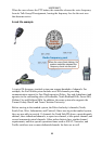
Location-based scanning allows you to control which sites and channel groups are
scanned based on your exact location. This frees you from having to manually
enable and disable systems or channel groups as you change location.
To use Location-Based scanning, you need to have the following:
the location for the center point for each site or channel group you want to
control
the radius or distance from the center point you want to set as the range for
each site or channel group
if you are scanning while traveling, you may want to include the heading
(direction) of travel
some type of mapping method. If you don't want to use paper maps, you
might try a mapping software (such as Microsoft® Streets and Trips or
Delorme® Street Atlas) that allows you to draw markings and overlays on
maps.
a GPS receiver with a serial data output (NMEA)
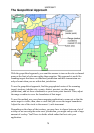
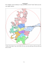
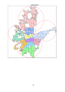
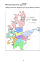
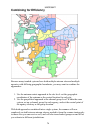
There are many different approaches you can use to determine where to place a
center point for a system/ site or channel group. The two most common are the
geopolitical approach and the antenna-centric approach. For large trunked systems,
you may find that a combination of these two approaches works best.