


UBCD396XT
70
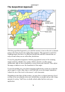
The Geopolitical Approach
With the geopolitical approach, you want the scanner to turn on the site or channel
group at the limit of relevance rather than reception. This approach is useful for
scanning targets that have a welldefined jurisdiction and their transmission are
only relevant when you are within that jurisdiction.
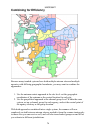
To use the geopolitical approach, find the geographical center of the scanning
target's territory (whether city, county, district, precinct, or other agency
jurisdiction), and set these coordinates as your center point location. Then, adjust
the range or radius to cover the boundaries of that target.
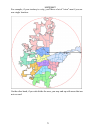
To use this method, use your chosen mapping application to zoom out so that the
entire target is visible, then, draw a circle that just covers the targets boundaries.
Adjust the size of the circle to the nearest ½ mile increment.
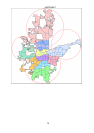
Depending on the shape of the territory, you may have to choose between a lot of
overlap or not covering the entire area: jurisdiction, you might end up with a large
amount of overlap. You'll have to decide which radius that best suits your
application.